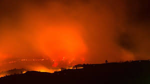
NEVADA COUNTY, CA — Firefighters are responding to a reported wildfire near Floriston in Nevada County, where the incident has been estimated at approximately 10 acres and is reportedly burning through rugged terrain.
Information from Incident Command indicates that the fire has been moving through a challenging ridge-and-canyon environment, with flames reported running along a ridge before moving downward into a canyon. The conditions are presenting additional challenges for crews working to slow the fire’s progression.
Fire Crews Face Difficult Ridge and Canyon Terrain
The terrain surrounding the Floriston area can create significant challenges during wildfire operations. Steep slopes, canyon formations and forested vegetation can make it more difficult for ground crews to reach portions of an active fire.
The reported fire behavior, with flames moving along a ridge and into a canyon, has required firefighters to work carefully as they attempt to control the incident and prevent further growth.
At this stage, the reported acreage remains an estimate and may change as firefighters and incident personnel continue assessing and mapping the fire perimeter.
Additional Air Tankers Requested
Air Attack has requested additional aerial firefighting resources to assist crews responding to the Floriston fire.
The request reportedly includes two additional air tankers. One is identified as a Type 1 aircraft, while the second is requested as a Type 3 or larger aircraft.
Aerial resources can provide support in areas where steep or inaccessible terrain makes direct ground operations more difficult. Their use may help crews slow advancing flames and provide additional opportunities for containment operations.
Helicopter Support Also Requested
Two additional helicopters have also reportedly been requested for the incident.
The request includes one Type 1 helicopter and another Type 2 or larger aircraft. Depending on operational conditions, helicopters can provide aerial water support and assist firefighting operations in difficult-to-access areas.
The additional aircraft requests indicate that incident personnel are seeking expanded aerial support while ground operations continue.
Floriston Area Draws Fire Response
Floriston is a small community in Nevada County near the Truckee River and east of Truckee. The surrounding landscape includes mountainous and forested areas, with steep terrain that can complicate wildfire suppression.
For firefighters, the geography can influence how crews approach the fire and where aircraft can provide support. Ridge lines, canyon areas and vegetation can also affect fire behavior depending on weather and fuel conditions.
Reported Fire Size Could Change
The approximately 10-acre figure should be regarded as an incident estimate based on the situation described by Incident Command at the time of the update.
Wildfire acreage can change rapidly during an active response. As crews establish the perimeter, conduct mapping and assess areas that may not initially be accessible, the reported size can be revised.
Fire behavior can also shift quickly, particularly when flames move through steep terrain.
Floriston Fire Details
| Detail | Information |
|---|---|
| Incident | Reported wildfire |
| Area | Near Floriston, Nevada County, California |
| Reported size | Approximately 10 acres |
| Terrain | Ridge and canyon terrain |
| Reported fire behavior | Flames running along a ridge and into a canyon |
| Air support | Additional resources requested |
| Air tankers requested | Two |
| Tanker specifications | One Type 1; one Type 3 or larger |
| Helicopters requested | Two |
| Helicopter specifications | One Type 1; one Type 2 or larger |
| Current status | Active response |
| Acreage status | Subject to change as the fire is mapped |
Response Remains Active
Firefighters and incident personnel remain focused on managing the reported wildfire and limiting additional spread. The requested air tankers and helicopters are intended to strengthen the response as crews contend with the difficult terrain.
Because the incident remains active, information concerning acreage, fire behavior, aircraft assignments and operational conditions may change as the response develops.
Residents and visitors in the surrounding area should follow any official evacuation, road-closure or emergency-safety instructions issued for the area if conditions change.
Disclaimer
This report is based on information available at the time of publication and may change as firefighting operations continue. Reported acreage, fire behavior, aircraft requests and other incident details may be revised as officials conduct further assessments. Readers should rely on current official emergency instructions for immediate safety decisions.